Parallel geo addressing & LuckyBlock ferries
How to combine commune/K-Station addressing with opportunistic routing (mobile ferries) to cross network outages without exposing final destinations.
Licences & Propriété — Licensing & Ownership
Œuvre propriétaire — Tous droits réservés. Copyright © 2024-2026 Yannick Mandaba-Masseron — SafeZone FPV™. Aucun usage, reproduction, distribution, modification ou travail dérivé sans accord écrit préalable du titulaire. Les termes HUSCI, Action RIC, La Commune Légiférante, GeoMANET, La Commune 2.0, M.S.Y. (Manet Secure You), ainsi que les logos, sigles et identités visuelles, sont des désignations propriétaires réservées de SafeZone FPV™.
Proprietary work — All rights reserved. Copyright © 2024-2026 Yannick Mandaba-Masseron — SafeZone FPV™. No use, reproduction, distribution, modification or derivative work without the rights holder's prior written authorization. The terms HUSCI, Action RIC, La Commune Légiférante, GeoMANET, La Commune 2.0, M.S.Y. (Manet Secure You), together with logos, acronyms and visual identities, are reserved proprietary designations of SafeZone FPV™.
Voir LICENSE & LICENSES/ à la racine du dépôt. Demandes : ip@safezone-fpv.com.
1. Goal
The purpose of parallel geographic addressing is to keep the mayorsâ network operating even if all regular telecoms are cut:
- by relying on geographic hubs (K/H stations) tied to communes,
- by circulating LuckyBlock bundles carried by people and vehicles,
- by hiding exact locations behind town halls and local relays.
2. Logical vs geographic addresses
2.1. Logical addresses (Obambu IDs)
Each mayor, citizen, or box has a logical identifier OBID-* managed on the local blockchain:
OBID-MAIRE-COMMUNE-123-4F9A2COBID-CITOYEN-COMMUNE-045-83D1B7OBID-AGENT-MOBILE-XYZ-77AC10
General structure: OBID-<type>-<commune>-<random>.
<commune>shows the commune of attachment, nothing more (not the village).<random>is a long random suffix revealing nothing about the position.
2.2. Parallel geographic addressing
Alongside these IDs, the network maintains a map by communes and hubs:
- Public level (on-chain): country, prefecture, commune, coarse geo cell (1010 km grid).
- K-Station level (private): villages, neighborhoods, served S/Home boxes.
- Fine GPS level (private): exact coordinates, only exchanged encrypted between trusted people (friends, NGOs, S-mobiles).
An external observer only sees: âthis message is for an ID served by commune X in that zoneâ, without knowing which village or house.
3. Layered manifests: what ferries see
For each LuckyBlock bundle, we build a manifest in two parts:
- Clear part (visible to all ferries):
- only exposes the macro layer: country then broad region served (never the commune yet),
- reminds the priority (P0..P3) and the TTL,
- lists bundle size and hash for integrity checks.
- Encrypted segments (readable only by certain hubs):
- each layer unveils one more step: sub-region, then commune, and only the last hop reveals the precise K station or hub,
- the ânext hopâ (K/H station or proxy) is encrypted with that hubâs public key,
- proxies/friends can be inserted between layers to blur the route or absorb traffic.
Outcome:
- a human ferry or phone only sees âfrom A to region B, priority P1, TTL 7 daysâ;
- the town hall in B, by decrypting its segment, discovers which sub-area or which OBID it must route to.
4. Opportunistic ferries: who carries what?
A ferry is any data carrier crossing zones: phone, S box, laptop, bus, motorbike, NGO, etc.
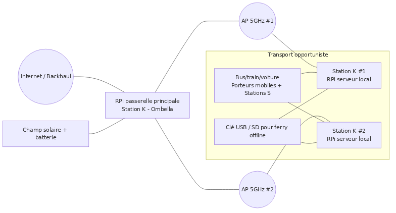
- Ferries carry bundles (signed, compressed LuckyBlock files).
- They do not read the encrypted content or detailed addresses.
- They only declare their route: âI go from region A to region B via this stationâ.
The ferry app (Termux, laptop, USB script) practically does:
- Scan bundles available at the departure station (K/H),
- Load those matching its destination or intermediate hubs,
- Drop these bundles at stations along the way,
- Pick up other bundles to take further.
Same idea as a DTN or a âdata muleâ: the bus or phone becomes a USB cable on legs.
5. Resilience in crisis
5.1. Network cuts & shelling
If Internet or long-distance radios go down, the commune/hub map keeps a network âin piecesâ alive:
- each commune continues to record acts and decisions locally,
- ferries move bundles from one hub to another along human travel,
- the event chain (local blockchain) stitches back together as soon as a ferry links two islands.
5.2. Coup dâtat or compromised branch
Official identities (mayors, prefects, essential services) are anchored in the first blocks. If a coup or capture happens:
- mayors keep an independent way to check who is still legitimate,
- they can decide to cut off a branch deemed compromised (special chain transactions),
- the mayorsâ forum continues to exist even if central infrastructure falls.
6. Practical routing & example cycle
6.1. Geographic hubs
A geographic hub is a K/H station declared with a commune ID and an approximate position (grid or blurred GPS).
- typical coverage radius: 10â15 km in LoS,
- point-to-point links possible between hubs via directional antennas.
6.2. Simplified example
Example of a P1 message from region A to a mayor in region B:
- K1 (region A) creates a bundle âregion B / commune 205, priority P1, TTL 7 daysâ.
- K1 encrypts a segment indicating the next target hub is K2 (bus station in B).
- A bus runs A â B; the bus ferry loads the bundle at K1, drops it at K2.
- K2 decrypts its segment, sees it must forward to K3 (village), by local WiâFi or another ferry.
- K3 uses its internal table to deliver the bundle to the mayorâs tablet
OBID-MAIRE-COMMUNE-205-XXXXXX. - The tablet emits an ACK that will itself be transported back, allowing the source to purge the bundle.
K1 (region A) --(bus LuckyBlock)--> K2 (region B) --(local ferry)--> K3 (village)
   |                                                               |
   |                  logical mesh (communes / OBID)               |
   '-------------- mayors forum, acts, votes ----------------------'